We needed another early start this morning to catch the tide down to and around Carsnore Point, which is the most south eastern part of Ireland. Between it and Tuskar Rock the tides run strongly with some dire warnings in the pilot book should the weather be poor, and also when in a wind against tide situation.
When planning this leg there were various options, one was to go right outside Tuskar Rock and miss the worst effect of the tide. Another was to go the inside route sticking close to Carsnore Point. I finally settled on a compromise, in that I would go between the point and Tuskar Rock, assess the effect of the tide, and if all was OK at the Barrels cardinal marker I would then cut inshore and go over between the marker buoys at St Patricks Bridge (gravel bank with 2 metres depth at lowest tide) and into Kilmore Quay.
Consideration had also to be given to the fact that we are moving onto Spring Tides which means stronger curents, and the charts were showing some tidal rips in certain areas. The final part of the equation was that as we cleared the point we would have the full effect of any wind from the south creating a wind against tide situation.
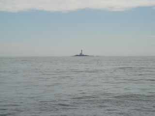
We set off early in a light F1/2 southerly wind and when the sun came up it was a lovely sunny day and we spotted a few Porpoise on the way down which will always brightens up the day. Everything was going to plan as we approached the gap between Tuskar Rock Lighthouse and the Carsnore Point, and as you can see from this photo the seas were calm.
Just after I took this photo the full effects of the tide kicked in, and the sea state changed. The wind was now only F3 (as we had cleared the shelter of the point) but the effect was dramatic, we were whoosing through at 10.5kts over the ground, and into some sizeable waves. It was perfectly safe in Sun Dog, but I could visualise just how hellish this would be in strong winds, especially bearing in mind how light the winds were today, and the sea state created!
Approaching Barrel buoy I had the binoculars out to look inshore, and all I could see was white water everywhere, therefore with no local knowledge I applied my mate John’s philosophy…….”if in doubt, bottle out” . Therefore our course was now to go the long way, and loop around the Saltee Islands and into Kilmore Quay. This would add a few hours to the day, but it was without doubt the safest option.
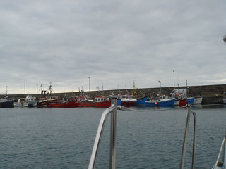
Rounding the Great Saltee Island we passed a load of boats out with Sea Anglers and began our approach. There are a few unmarked rocks to be avoided in the approach, and the leading lights are noted on the chart at a very precise 7.8 degrees true! To be fair once the safe water mark is reached the leading marks are clearly visable and the only thing that required care was the force of the tide, as we had arrived after the turn of the tide. We were running/crabbing down the leading marks with the bow some 30 degress to starboard of the marks. The turn into the harbour is sharply to port with dire consequences if you overshoot as there are nice jaggy rocks and shallows all waiting to spoil your day 🙂
This harbour is my kind of place, as it has a good atmosphere. It is busy with small commercial fishing boats, and it also has a sizeable number of boats taking out sea anglers.
As we were pretty tired we took a cursory look around the town and found a Seafood Restaurant called Silver Fox which has a number of awards including one saying it is Irelands Best Seafood Restaurant…………..guess where we will be eating tomorrow night?